
I have four things to say about this.
Houston developers plan to build a mixed-use project, including upscale apartments and retail, on a 15-acre tract close to downtown, replacing a large produce warehouse that’s occupied the space for decades.
Capcor Partners and Kaplan Management bought the land this week from Grocers Supply, which has been at the corner of Studemont and Interstate 10 for 42 years.
[…]
Josh Aruh of Capcor, which specializes in retail developments, said it’s rare to find such a large piece of land in the Inner Loop and added that the project will make a “big footprint.”
“There is tremendous, continuous demand in this sub-market,” Aruh said. “We believe the scarcity of such a large, contiguous tract so close to downtown Houston, the Heights and entertainment districts is primed for a strong multifamily component. And with frontage near I-10, this property is ideally suited for retail. The size of the tract invites many possible other uses and users that we are currently exploring.”
Aruh said he has already discussed possibilities for the property with grocers, cinemas, restaurants and several big box retailers.
The developers are also working with the city to expand a street to split the property and reduce traffic, he said.
Michael Kaplan of Kaplan Management, which specializes in multifamily developments, said he hopes to build up to 400 high-end apartments, to go with the retail and commercial uses, to meet the demand for housing in the area.
“It’s just in the heart of this terrific growth corridor,” Kaplan said. “It is such a strong area.”
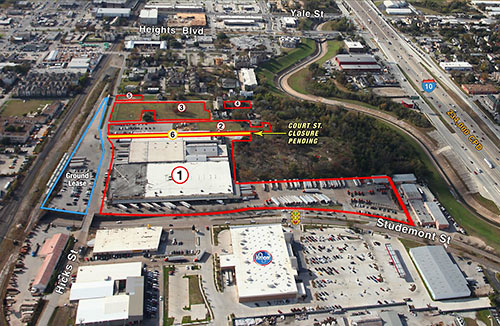
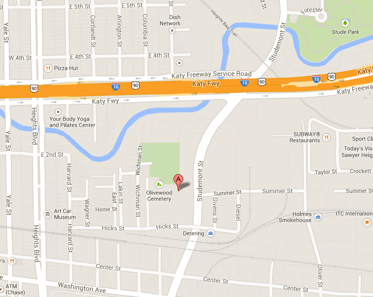
1. I admire their desire to have as small an impact on traffic as possible, because traffic on the stretch of Studemont between Washington and I-10 sucks thanks to the Kroger, the long light cycle at I-10, and the huge number of cars turning left to get onto I-10 and to get into the Kroger. Let me suggest that the first order of business would be to rebuild that piece of road, because it’s axle-breaking awful right now. Yeah, that’ll make traffic even worse for the duration, but the gain will be worth the pain. As for expanding a street – not sure which one they have in mind – let me suggest that what they really ought to consider is adding a street. I presume the entrance to this new development would be opposite the entrance to the Kroger where the traffic light is and where there’s already a left turn lane on northbound Studemont, which currently turns into a wall. Having that entrance street connect to Wichman on the west so that vehicles can access Hicks Street, which passes over Studemont and which connects to Heights via Harvard, will help.
2. If you really want to lessen the impact on traffic in the area, then it’s vital to ensure non-vehicular mobility into and out of this development and to the surrounding areas, by which I specifically mean Washington and White Oak. First and foremost, put in a sidewalk on the west side of Studemont, along the front of the development. There’s already a decent sidewalk on the east side of Studemont, but it terminates immediately north of I-10, where a well-worn path in the dirt connects you up with the bridge over the bayou and the continuation of the sidewalk at Stude Street. That new sidewalk could split at the underpass to give pedestrians the option of continuing on Studemont to Washington or ascending to Hicks and the overpass for better access to Arne’s and Kroger, and on to Sawyer Street if one is adventurous. I took the #50 bus home from work on Friday when this story was run, and I got off at Studemont to walk home from there. It took me 15 minutes to get from Washington to White Oak – I timed it – so having good pedestrian paths between these two streets will make the new development a lot more accessible. Given the traffic and the parking situation on either end, you’d be better off walking from whatever residence they build to Fitzgerald’s or BB’s or wherever you want to go.
3. At least as important as facilitating pedestrians is connecting this development to the existing bike paths and bike lanes nearby. You could take Hicks to Heights and from there get on the Heights Bike Trail, but that’s a mighty big detour if you’re heading towards downtown. And Lord knows, no one in their right mind would want to bike on Studemont to get anywhere. Look at a map of the area. Isn’t the solution to all this obvious?
This just screams for a new trail along the bayou to get past I-10 and eventually hook up with the existing trails. This picture shows how that would be possible:
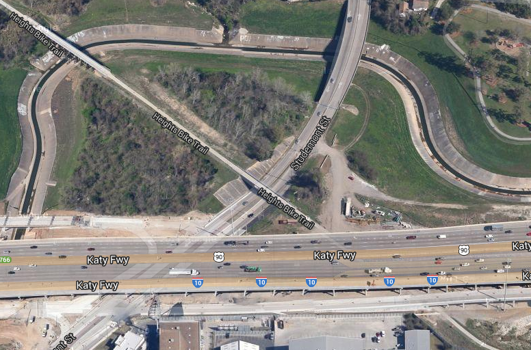
Pass under Studemont, and pave that truck path to get to the Heights trail. You’d need to build a bridge over the bayou to connect to the new trail adjacent to Stude Park, which you can’t see in this old Google satellite image, but that shouldn’t be a big deal. I have no idea how much this all might cost, but for something like this that enhances mobility there may be federal grant money available. Or, you know, maybe the developers can kick in on this, since it would greatly enhance the value of their property. This might in fact be an excellent candidate for 380 agreement, one that would offer a clear benefit to all involved. I’m sure there’s a way to make this work.
Ed Wulfe, chairman and CEO of retail development and brokerage firm Wulfe & Co., said as Houston becomes more dense and urban, more warehouses will be converted into residential and commercial properties.
“We are changing land-use patterns,” Wulfe said. “Now the need is greater and the market is stronger. Warehouses can only command so much economic benefit.”
4. Density with transit >>> density without transit. The good people of Super Neighborhood 22 have that comprehensive transportation plan for their area that includes various rail and streetcar options for the Washington Avenue corridor. Moving forward on that would be a huge boon to mobility in the area, and to projects like this one and the ones that will inevitably follow. Look, I know people get skeptical whenever non-car modes of transportation are discussed. Most people don’t want to give up their cars, even a little bit. I get that, but in a city this size that still leaves a whole lot of folks who do want alternatives, and these are the people who will be seeking out dense development. We can do it right and make the whole experience a hell of a lot better, which includes the drivers since they’ll have fewer competitors for road space, or we can do it wrong and make a huge mess of it all. You tell me what the right answer is. Swamplot has more.
There are already plans for a bridge across the bayou, the land has been worked for months now. The Bayou Greenway folks told me that the stretch from there to Heights Blvd and beyond up to a future park just North of I-10(West of Yale) is planned BUT, it is chopped into several segments which are funded and managed by separate entities, so as usual there will be slow progress.
“This just screams for a new trail along the bayou to get past I-10 and eventually hook up with the existing trails”
This is part of the Bayou Greenways 2020 plan:
http://www.bayougreenways.org/updates
The full White Oak Bayou map seems to be broken, but they are making the connection between the bayou trail and the MKT trail this year.
Hmm, didn’t see Northsider’s comment when I posted.