Houston’s expanding trail system will soon gain a new leg in the greater Heights area.
The addition will be part of Bayou Greenways 2020, a $215 million project aimed at creating a continuous network of hike-and-bike trails and parks along the city’s 10 major bayous.
“This is just one critical piece that will be a great help to the Heights area and the White Oak Bayou trail system,” said Heights resident Kevin Shanley, a former president of the White Oak Preservation Association.
The current trail along White Oak Bayou originally ran from 11th Street north to Watonga. As it grew in popularity, it was extended north from Watonga to Antoine. The expansion was completed last year.
In addition, a downstream section has been added from Stude Park to the University of Houston-Downtown campus.
Also in place is the Heights Hike & Bike Trail, which runs along the Missouri-Kansas-Texas rail line in the Heights from south of 11th Street near Eureka across the Heights community.
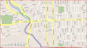
The planned section of trail, 1.35 miles, will connect the Heights segment to the existing White Oak Bayou Trail. The project will include replacing a burnt-out bridge over White Oak Bayou. Groundbreaking on this section will take place this fall, Shanley said. The work could be done by fall 2014.
“When the first leg is complete, you’ll be able to ride from (the University of Houston-Downtown) all the way to Antoine,” he said.
Ultimately, the trail will extend much further west/northwest than that, but it’s the connection between the MKT (Heights) and White Oak trails that specifically interests me. I wrote about this two years ago in response to an earlier story by Marty Hajovsky about the effort to link these trails. In the embedded image above, it’s the purple line that represents what is to be built. Making that connection will do a lot to expand bike transit in this area, and I’m delighted to see it happen.
One of the many nice things about these trails is that for the most part they are off the streets and separated from traffic, which makes riding on them quite safe. There are places where the MKT and Nicholson trails in the Heights do cross streets, and in some places those crossings are a bit hazardous. In an earlier entry, Hajovsky wrote about efforts by the neighborhood to mitigate the dangers at these crossings.
Last month, the HHA board sent a letter to District C City Council Member Ellen Cohen, Mayor Annise Parker and other city officials calling for safety improvements at six locations where the Nicholson/SP and MKT Rails to Trails bike trails cross major streets. For those of us who use those paths regularly, frequently with kids, as well as those of us who cross those paths in cars regularly (raising hands as I’m included in both of these groups), this would be a major improvement.
The six locations were identified in an independent traffic engineering study obtained by the Heights Association. According to a report in the HHA newsletter that goes out to members, the group claims that the changes should “enhance the safety of bicyclists and pedestrians without significant delays to motorists.” Here’s an excerpt from that newsletter:
The study recommends (1) installation of pedestrian hybrid beacons (“HAWK lights”) where the trail crosses Heights Boulevard, Yale, West 11th, West 19th, and West 20th; (2) installation of in-roadway lighting where the trail crosses White Oak, and (3) enhanced traffic signals and pavement markings at all six crossings. We note that the City has recently installed “bike crossing” pavement markings on the roadway approaches to the MKT intersections at 7th and Yale, 11th and Nicholson, and Columbia and White Oak.
Driving and riding over those six sites frequently, the safety problems are obvious. At West 19th, the Nicholson/SP trail splits from a single trail north of West 19th, to a split trail on both sides of the street to the south. It is so common to see children on bicycles, jogger or walkers darting across the road there to avoid oncoming traffic.
And since the bike trail covers what once were railroad tracks, the trail is on something of a rise in the street at all six of these locations. That makes the bike path hard to make out for oncoming drivers, whose cars are already “at pace” along all six of those streets. On white Oak and West 19th, with the shops, restaurants and bars, there are plenty of distractions already, further endangering trail users.
I personally would rank the intersections at Yale and 11th as the most dangerous because they’re the busiest and fastest-moving. Heights is basically two separate one-way streets, and I find that a lot easier to cross safely, and there isn’t as much traffic on 19th and 20th in my experience. The HAWK signals are still a good idea for all the locations – I’d like one installed at that White Oak crossing, too – but if I had to prioritize them, that’s how I’d do it. Houstonia has more.


What would be really nice is if the MKT trail were connected to the Heritage Corridor Bayou Trail at Stude Park. The Heritage Corridor Bayou Trail gives access from the Heights to Downtown without crossing a single street. I’ve been waiting and hoping for two years that the connection will be made under the Studemont street bridge. Still waiting…