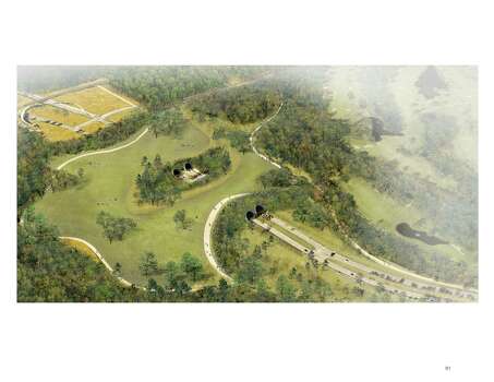
Some fascinating ideas for ensuring the long-term health of Memorial Park.
Today Memorial Park is a land divided.
The city’s premiere park stretches across 1,500 acres, almost twice as large as New York’s Central Park. But to Thomas Woltz of the internationally renowned landscape architecture firm Nelson Byrd Woltz, it feels much smaller. Over time the land has been divided into 24 tracts by roads, an elevated railroad, a power easement and recreational amenities.
That could change during the next 20 years if a long-range master plan being proposed by Woltz’s firm is adopted next spring by the Houston City Council. Hired in 2013 by the Houston Parks and Recreation Department, the Uptown Houston tax increment reinvestment zone and the privately funded Memorial Park Conservancy, the firm is nearly three months into a 10-month design process.
At a public meeting Wednesday, Woltz presented his firm’s initial design strategies and the reasoning behind them – ideas driven by previous public input and a year’s research by a team of about 70 local experts in fields like soil science, ecology, history and archaeology.
He shared maps, drawings and aerial views to explain the park’s ecological and cultural histories, also unveiling a dramatic solution to one of the landscape’s biggest problems. He’s proposing a grass- and tree-covered land bridge, 800 feet long, that would rise gently across Memorial Drive, over a tunnel, to reconnect the park’s north and south sides.
While it’s not realistic to remove the street, which is crucial to Houston’s traffic circulation, the land bridge is “a kind of triumph … the park wins,” Woltz said.
The current pedestrian bridge on the park’s western side, completed in 2009, was an important first gesture toward stitching the park’s landscape back together, Woltz said. “This land bridge builds on that beginning at a much larger scale.”
[…]
Project director Sarah Newbery of Uptown Houston said the Uptown Houston TIRZ is committed to spending $100 million to $150 million on the restoration projects and infrastructure; a figure that could change with property values. Memorial Park Conservancy executive director Shellye Arnold said her group is studying how much it can raise in the next 10 or 20 years toward the effort.
“But we think of this in terms of a 100-year or 75-year plan. We’ll execute large parts of it in the next three to 15 years; but there can be a road map for the next generation as well.”
Woltz expects to reveal designs that incorporate Camp Logan remnants at the next public meeting on Nov. 10.
“We’re looking for ways the landscape could function as a memorial to the soldiers and maybe even reveal some of the grid,” he said.
A Jan. 12 meeting is titled “Spaces and Places: How Will It Look?” The final March 9 meeting promises a more comprehensive revealing of the plan.
See here, here, and here for some background. The TIRZ in question is also the one helping to fund the Uptown BRT line. Some more material from the architect is here. What do you think about this? Link via Swamplot.

